
Thank you for supporting this site ❤️
Make a donation
Make a donation
Appleton topographic map
Click on the map to display elevation.
Thank you for supporting this site ❤️
Make a donation
Make a donation
About this map
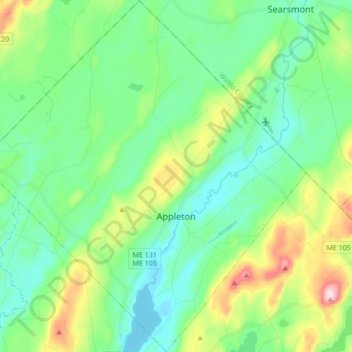
Name: Appleton topographic map, elevation, terrain.
Location: Appleton, Knox County, Maine, United States (44.24205 -69.34662 44.36466 -69.18761)
Average elevation: 105 m
Minimum elevation: 23 m
Maximum elevation: 332 m
Thank you for supporting this site ❤️
Make a donation
Make a donation
Other topographic maps
Click on a map to view its topography, its elevation and its terrain.