
Bondowoso topographic map
Interactive map
Click on the map to display elevation.
About this map
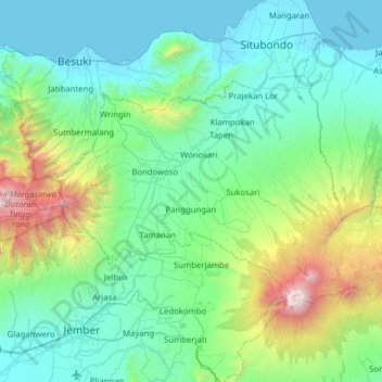
Name: Bondowoso topographic map, elevation, terrain.
Location: Bondowoso, East Java, Indonesia (-8.13381 113.62326 -7.75652 114.24879)
Average elevation: 554 m
Minimum elevation: 0 m
Maximum elevation: 3,285 m
Other topographic maps
Click on a map to view its topography, its elevation and its terrain.
East Java
East Java has a tropical monsoon and savanna climate at lower elevation and subtropical at higher elevation. Compared with the western part of Java Island, East Java in general has less rainfall. Average rainfall is 1,900 mm per year, with a rainy season during the 100 days. The average temperature ranges…
Average elevation: 67 m