
West Virginia topographic map
Interactive map
Click on the map to display elevation.
About this map
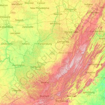
Name: West Virginia topographic map, elevation, terrain.
Location: West Virginia, United States of America (37.20148 -82.64474 40.63880 -77.71903)
Average elevation: 430 m
Minimum elevation: 84 m
Maximum elevation: 1,452 m
West Virginia is located entirely within the Appalachian Region, and the state is almost entirely mountainous, giving reason to the nickname The Mountain State and the motto Montani Semper Liberi ("Mountaineers are always free"). The elevations and ruggedness drop near large rivers like the Ohio River or Shenandoah River. About 75% of the state is within the Cumberland Plateau and Allegheny Plateau regions. Though the relief is not high, the plateau region is extremely rugged in most areas. The average elevation of West Virginia is approximately 1,500 feet (460 m) above sea level, which is the highest of any U.S. state east of the Mississippi River.
Other topographic maps
Click on a map to view its topography, its elevation and its terrain.
Huntington
United States of America > West Virginia > Huntington
Huntington, Cabell County, West Virginia, United States of America
Average elevation: 218 m