
Thank you for supporting this site ❤️
Make a donation
Make a donation
Mashqita topographic map
Click on the map to display elevation.
Thank you for supporting this site ❤️
Make a donation
Make a donation
About this map
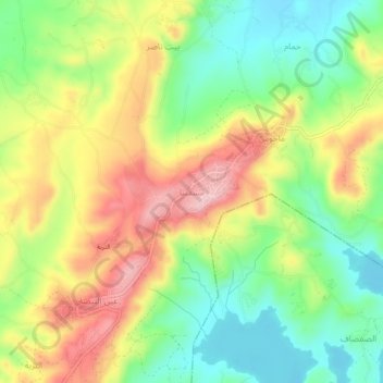
Name: Mashqita topographic map, elevation, terrain.
Average elevation: 155 m
Minimum elevation: 62 m
Maximum elevation: 271 m
Thank you for supporting this site ❤️
Make a donation
Make a donation
Other topographic maps
Click on a map to view its topography, its elevation and its terrain.
Citadel of Salah Ed-Din (Saladin Castle)
Syria > Latakia Governorate > Daryus
Average elevation: 408 m