
Thank you for supporting this site ❤️
Make a donation
Make a donation
Glady topographic map
Click on the map to display elevation.
Thank you for supporting this site ❤️
Make a donation
Make a donation
About this map
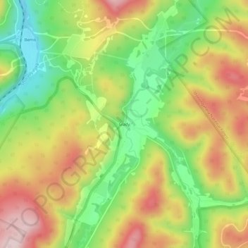
Name: Glady topographic map, elevation, terrain.
Location: Glady, Randolph County, West Virginia, 26268, United States (38.77844 -79.73950 38.81844 -79.69950)
Average elevation: 943 m
Minimum elevation: 776 m
Maximum elevation: 1,123 m
Thank you for supporting this site ❤️
Make a donation
Make a donation
Other topographic maps
Click on a map to view its topography, its elevation and its terrain.