
Painswick topographic map
Interactive map
Click on the map to display elevation.
About this map
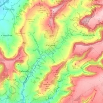
Name: Painswick topographic map, elevation, terrain.
Average elevation: 163 m
Minimum elevation: 36 m
Maximum elevation: 280 m
Other topographic maps
Click on a map to view its topography, its elevation and its terrain.
Leckhampton
Verenigd Koninkrijk > Engeland > Gloucestershire > Cheltenham
Leckhampton, Cheltenham, Gloucestershire, Engeland, GL53 0PF, Verenigd Koninkrijk
Average elevation: 118 m
Birdlip
Verenigd Koninkrijk > Engeland > Gloucestershire > Cotswold
Birdlip, Cotswold, Gloucestershire, Engeland, Verenigd Koninkrijk
Average elevation: 261 m