
Thank you for supporting this site ❤️
Make a donation
Make a donation
Deer Park topographic map
Click on the map to display elevation.
Thank you for supporting this site ❤️
Make a donation
Make a donation
About this map
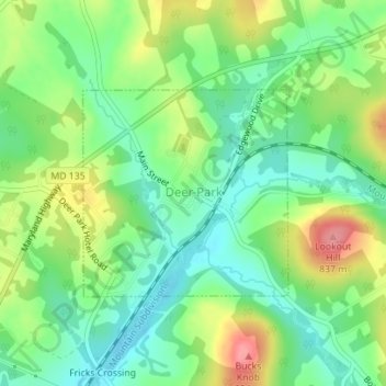
Name: Deer Park topographic map, elevation, terrain.
Location: Deer Park, Garrett County, Maryland, United States (39.41677 -79.33516 39.43126 -79.31656)
Average elevation: 774 m
Minimum elevation: 737 m
Maximum elevation: 834 m
Thank you for supporting this site ❤️
Make a donation
Make a donation
Other topographic maps
Click on a map to view its topography, its elevation and its terrain.