
Thank you for supporting this site ❤️
Make a donation
Make a donation
Cole Mill topographic map
Click on the map to display elevation.
Thank you for supporting this site ❤️
Make a donation
Make a donation
About this map
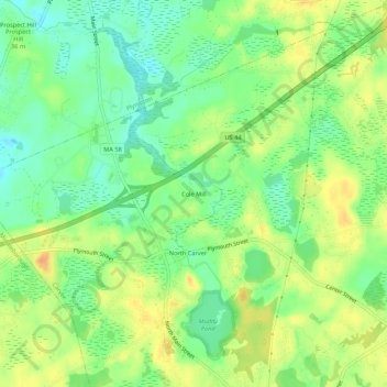
Name: Cole Mill topographic map, elevation, terrain.
Average elevation: 34 m
Minimum elevation: 16 m
Maximum elevation: 54 m
Thank you for supporting this site ❤️
Make a donation
Make a donation
Other topographic maps
Click on a map to view its topography, its elevation and its terrain.
Sampson Pond
United States > Massachusetts > Plymouth County > Carver > South Carver
Average elevation: 28 m