
Thank you for supporting this site ❤️
Make a donation
Make a donation
Boisdorfer Siedlung topographic map
Click on the map to display elevation.
Thank you for supporting this site ❤️
Make a donation
Make a donation
About this map
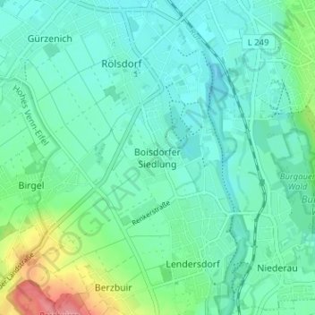
Name: Boisdorfer Siedlung topographic map, elevation, terrain.
Average elevation: 143 m
Minimum elevation: 124 m
Maximum elevation: 210 m
Thank you for supporting this site ❤️
Make a donation
Make a donation
Other topographic maps
Click on a map to view its topography, its elevation and its terrain.
Arnoldsweiler
Deutschland > Nordrhein-Westfalen > Kreis Düren > Düren
In der Nähe von Arnoldsweiler, und zwar westlich des Ortes und im Südostwinkel zwischen der A4 und der Bahnlinie Düren-Jülich bei der Höhe 120,6 befand sich eine nur beschränkt ausgebaute Batteriestellung der Luftverteidigungszone West. In der Hauptstellung konnten vier Unterstände nachgewiesen werden.…
Average elevation: 122 m
Thank you for supporting this site ❤️
Make a donation
Make a donation