Geolocate

Ross More topographic map

Click on the map to display elevation.

About this map

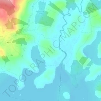
Name: Ross More topographic map, elevation, terrain.

Location: Ross More, Mahanagh ED, Manorhamilton Municipal District, County Leitrim, Connacht, Ireland (54.16185 -8.05629 54.17044 -8.04302)

Average elevation: 60 m

Minimum elevation: 42 m

Maximum elevation: 147 m

Other topographic maps

Click on a map to view its topography, its elevation and its terrain.

Rossinver

Ireland > County Leitrim

Average elevation: 91 m

Bornacoola

Ireland > County Leitrim

Average elevation: 47 m

Glenfarne

Ireland > County Leitrim

Average elevation: 90 m

Rossinver

Ireland > County Leitrim

Average elevation: 91 m

Drumshanbo

Ireland > County Leitrim

Average elevation: 66 m

Glenfarne

Ireland > County Leitrim

Average elevation: 90 m

Glencar Waterfall

Ireland > County Leitrim

Average elevation: 180 m

Glenade

Ireland > County Leitrim

Average elevation: 163 m

The Spit

Ireland > County Leitrim

Average elevation: 60 m

Knockacullion

Ireland > County Leitrim

Average elevation: 443 m

Lough Nacarriga

Ireland > County Leitrim

Average elevation: 73 m

Cloone

Ireland > County Leitrim

Average elevation: 65 m

Keeloges

Ireland > County Leitrim

Average elevation: 250 m

Ross Lough

Ireland > County Leitrim

Average elevation: 69 m