
Thank you for supporting this site ❤️
Make a donation
Make a donation
Millerville topographic map
Click on the map to display elevation.
Thank you for supporting this site ❤️
Make a donation
Make a donation
About this map
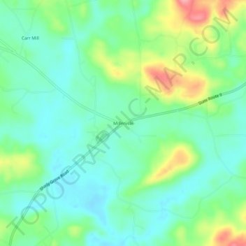
Name: Millerville topographic map, elevation, terrain.
Location: Millerville, Clay County, Alabama, 36267, United States (33.17151 -85.94580 33.21151 -85.90580)
Average elevation: 262 m
Minimum elevation: 230 m
Maximum elevation: 336 m
Thank you for supporting this site ❤️
Make a donation
Make a donation
Other topographic maps
Click on a map to view its topography, its elevation and its terrain.