
Thank you for supporting this site ❤️
Make a donation
Make a donation
Danube topographic map
Click on the map to display elevation.
Thank you for supporting this site ❤️
Make a donation
Make a donation
About this map
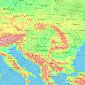
Name: Danube topographic map, elevation, terrain.
Location: Danube, Serbia (43.62003 8.51688 49.03137 29.77732)
Average elevation: 317 m
Minimum elevation: -5 m
Maximum elevation: 3,610 m
Thank you for supporting this site ❤️
Make a donation
Make a donation
Other topographic maps
Click on a map to view its topography, its elevation and its terrain.
Rajac
Serbia > Central Serbia > Bor Administrative District > Negotin Municipality
Average elevation: 127 m
Trstenik
Serbia > Central Serbia > Rasina Administrative District > Trstenik Municipality > Trstenik
Average elevation: 263 m