
Thank you for supporting this site ❤️
Make a donation
Make a donation
Refega topographic map
Click on the map to display elevation.
Thank you for supporting this site ❤️
Make a donation
Make a donation
About this map
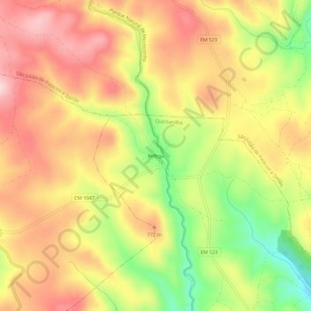
Name: Refega topographic map, elevation, terrain.
Location: Refega, Quintanilha, Bragança, Distrito de Bragança, Portugal (41.76284 -6.61090 41.80284 -6.57090)
Average elevation: 731 m
Minimum elevation: 593 m
Maximum elevation: 833 m
Thank you for supporting this site ❤️
Make a donation
Make a donation