
Meursault topographic map
Click on the map to display elevation.
About this map
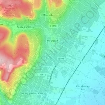
Name: Meursault topographic map, elevation, terrain.
Average elevation: 267 m
Minimum elevation: 197 m
Maximum elevation: 462 m
Other topographic maps
Click on a map to view its topography, its elevation and its terrain.
Sous Les Coteaux de Charmo
France > Bourgogne – Franche-Comté > Côte-d'Or > Avot
Average elevation: 411 m
Mont Auxois
France > Bourgogne – Franche-Comté > Côte-d'Or > Alise-Sainte-Reine
Average elevation: 307 m
Bierre en Morvan
France > Bourgogne – Franche-Comté > Côte-d'Or > La Roche-en-Brenil
Average elevation: 385 m
Le Cailleret
France > Bourgogne – Franche-Comté > Côte-d'Or > Puligny-Montrachet
Average elevation: 276 m
Au Faubourg
France > Bourgogne – Franche-Comté > Côte-d'Or > Flavigny-sur-Ozerain
Average elevation: 379 m
Auvillard
France > Bourgogne – Franche-Comté > Côte-d'Or > Saint-Victor-sur-Ouche
Average elevation: 438 m