
Thank you for supporting this site ❤️
Make a donation
Make a donation
Baton Rouge topographic map
Click on the map to display elevation.
Thank you for supporting this site ❤️
Make a donation
Make a donation
Baton Rouge
The city of Baton Rouge lies on the banks of the Mississippi River in southeastern Louisiana's Florida Parishes region. The city is about 79 miles (127 km) from New Orleans, 126 miles (203 km) from Alexandria, 56 miles (90 km) from Lafayette and 250 miles (400 km) from Shreveport. It is also 173 miles (278 km) from Jackson, Mississippi and 272 miles (438 km) from Houston, Texas. Baton Rouge lies on a low elevation of 56 to a little over 62 feet above sea level.
Thank you for supporting this site ❤️
Make a donation
Make a donation
About this map
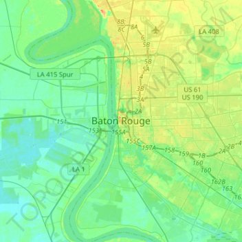
Name: Baton Rouge topographic map, elevation, terrain.
Average elevation: 12 m
Minimum elevation: 1 m
Maximum elevation: 37 m
Thank you for supporting this site ❤️
Make a donation
Make a donation