
Thank you for supporting this site ❤️
Make a donation
Make a donation
Cossall topographic map
Click on the map to display elevation.
Thank you for supporting this site ❤️
Make a donation
Make a donation
About this map
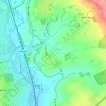
Name: Cossall topographic map, elevation, terrain.
Location: Cossall, Broxtowe, Nottinghamshire, England, United Kingdom (52.96638 -1.29747 52.98965 -1.25252)
Average elevation: 70 m
Minimum elevation: 43 m
Maximum elevation: 137 m
Thank you for supporting this site ❤️
Make a donation
Make a donation
Other topographic maps
Click on a map to view its topography, its elevation and its terrain.
Manor House Pond
United Kingdom > England > Nottinghamshire > Broxtowe > Bramcote
Average elevation: 57 m
Thank you for supporting this site ❤️
Make a donation
Make a donation
Nottingham Canal Local Nature Reserve
United Kingdom > England > Nottinghamshire > Broxtowe
Average elevation: 66 m
Attenborough Nature Reserve
United Kingdom > England > Nottinghamshire > Broxtowe > Beeston
Average elevation: 34 m