
Thank you for supporting this site ❤️
Make a donation
Make a donation
Weinbergen topographic map
Click on the map to display elevation.
Thank you for supporting this site ❤️
Make a donation
Make a donation
Weinbergen
The municipality of Weinbergen adjoined the urban area of Mühlhausen to the northwest. To the north-east it bordered on Körner, to the south-east on the administrative community of Unstrut-Hainich and to the west on the rural municipality of Vogtei. The municipality's altitude ranged from 182 m (597 ft) above NN on the Unstrut near Seebach to 389.8 m (1,279 ft) above NN on the Forstberg hill in the north.
Thank you for supporting this site ❤️
Make a donation
Make a donation
About this map
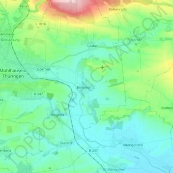
Name: Weinbergen topographic map, elevation, terrain.
Average elevation: 223 m
Minimum elevation: 174 m
Maximum elevation: 397 m
Thank you for supporting this site ❤️
Make a donation
Make a donation