
Thank you for supporting this site ❤️
Make a donation
Make a donation
Sibulan topographic map
Click on the map to display elevation.
Thank you for supporting this site ❤️
Make a donation
Make a donation
About this map
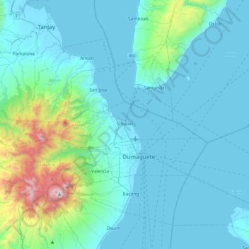
Name: Sibulan topographic map, elevation, terrain.
Location: Sibulan, Negros Oriental, Central Visayas, 6201, Philippines (9.31935 123.00174 9.39503 123.41008)
Average elevation: 217 m
Minimum elevation: 0 m
Maximum elevation: 1,822 m
Thank you for supporting this site ❤️
Make a donation
Make a donation
Other topographic maps
Click on a map to view its topography, its elevation and its terrain.
Thank you for supporting this site ❤️
Make a donation
Make a donation
Thank you for supporting this site ❤️
Make a donation
Make a donation
Thank you for supporting this site ❤️
Make a donation
Make a donation
Pamplona
Mountain ridges overlooking the plains of Pamplona, can be an object for viewers of scenic beauties. Nabalabag ridge, located at an elevation of 800 m above sea level at barangay San Isidro, overlooks on the west at municipalities of Bayawan and Santa Catalina and in the east, with the town of Pamplona, Tanjay…
Average elevation: 61 m
Thank you for supporting this site ❤️
Make a donation
Make a donation