
Thank you for supporting this site ❤️
Make a donation
Make a donation
Vorderlauben topographic map
Click on the map to display elevation.
Thank you for supporting this site ❤️
Make a donation
Make a donation
About this map
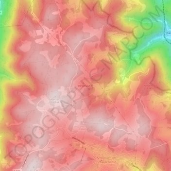
Name: Vorderlauben topographic map, elevation, terrain.
Average elevation: 886 m
Minimum elevation: 513 m
Maximum elevation: 1,016 m
Thank you for supporting this site ❤️
Make a donation
Make a donation
Other topographic maps
Click on a map to view its topography, its elevation and its terrain.
78136
Deutschland > Baden-Württemberg > Schwarzwald-Baar-Kreis > Schonach im Schwarzwald
Average elevation: 878 m