
Thank you for supporting this site ❤️
Make a donation
Make a donation
Burslem topographic map
Click on the map to display elevation.
Thank you for supporting this site ❤️
Make a donation
Make a donation
About this map
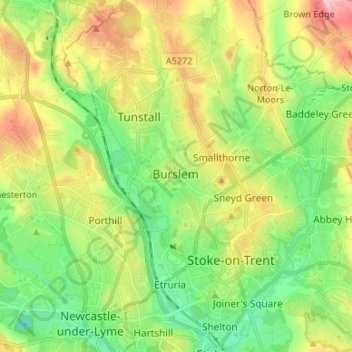
Name: Burslem topographic map, elevation, terrain.
Location: Burslem, Stoke-on-Trent, England, ST6 3EA, United Kingdom (53.00510 -2.23614 53.08510 -2.15614)
Average elevation: 157 m
Minimum elevation: 88 m
Maximum elevation: 271 m
Thank you for supporting this site ❤️
Make a donation
Make a donation
Other topographic maps
Click on a map to view its topography, its elevation and its terrain.
Biddulph Valley Line
United Kingdom > England > Stoke-on-Trent > Hanley > Eaton Park
Average elevation: 138 m
Thank you for supporting this site ❤️
Make a donation
Make a donation