
Thank you for supporting this site ❤️
Make a donation
Make a donation
Rheinkamp topographic map
Click on the map to display elevation.
Thank you for supporting this site ❤️
Make a donation
Make a donation
About this map
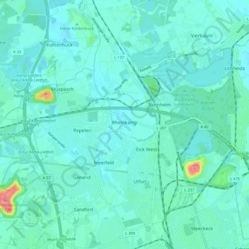
Name: Rheinkamp topographic map, elevation, terrain.
Average elevation: 27 m
Minimum elevation: 15 m
Maximum elevation: 99 m
Thank you for supporting this site ❤️
Make a donation
Make a donation
Other topographic maps
Click on a map to view its topography, its elevation and its terrain.
Halde Rheinpreußen
Deutschland > Nordrhein-Westfalen > Kreis Wesel > Moers
Die Halde Rheinpreußen ist eine 74 m über Umgebungsniveau aufgeschüttete Bergehalde in Moers-Meerbeck. Sie hat eine Gesamthöhe von 103 m ü. NN. Eigentümer ist seit dem Jahr 2001 der Regionalverband Ruhr.
Average elevation: 30 m