
Make a donation
Sweden topographic map
Click on the map to display elevation.
Make a donation
Sweden
Sweden's topography is a diverse tapestry shaped by ancient geological processes and glacial activity. In the west, the Scandinavian Mountains form a natural border with Norway, featuring peaks like Kebnekaise, the country's highest point at approximately 2,097 meters. Moving eastward, the terrain transitions into vast forests and rolling hills, interspersed with numerous lakes—Sweden boasts around 95,700 lakes, including Vänern and Vättern, two of Europe's largest. The central region, known as the Central Swedish lowland, is characterized by fertile plains that support agriculture, while the southernmost area, particularly Skåne, features flat, arable lands reminiscent of neighboring Denmark. Along the eastern coastline, the landscape is dotted with archipelagos, comprising thousands of islands and islets, adding to the country's intricate coastal geography. This varied terrain not only defines Sweden's natural beauty but also influences its climate, biodiversity, and human settlement patterns.
Make a donation
About this map
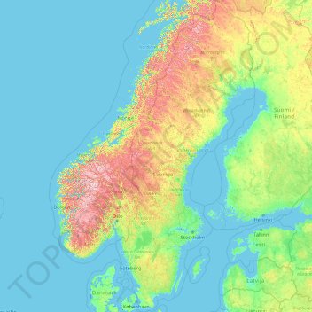
Name: Sweden topographic map, elevation, terrain.
Location: Sweden (55.13312 10.59310 69.05997 24.17768)
Average elevation: 163 m
Minimum elevation: -3 m
Maximum elevation: 2,098 m
Make a donation
Other topographic maps
Click on a map to view its topography, its elevation and its terrain.