
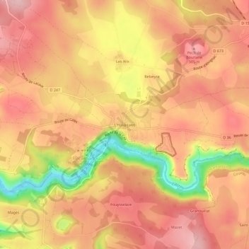
L'Hospitalet topographic map
Interactive map
Click on the map to display elevation.
About this map
Name: L'Hospitalet topographic map, elevation, terrain.
Average elevation: 257 m
Minimum elevation: 130 m
Maximum elevation: 319 m
Other topographic maps
Click on a map to view its topography, its elevation and its terrain.
Fouysselaze
France > Occitanie > Lot > Rocamadour
Fouysselaze, Rocamadour, Gourdon, Lot, Occitanie, France métropolitaine, 46500, France
Average elevation: 254 m
La Vitalie
France > Occitanie > Lot > Rocamadour
La Vitalie, Rocamadour, Gourdon, Lot, Occitanie, France métropolitaine, 46500, France
Average elevation: 218 m
Le coin du photographe
France > Occitanie > Lot > Rocamadour > L'Hospitalet
Le coin du photographe, Chemin du Photographe, L'Hospitalet, Rocamadour, Gourdon, Lot, Occitanie, France métropolitaine, 46500, France
Average elevation: 248 m
La Gardelle
France > Occitanie > Lot > Rocamadour
La Gardelle, Rocamadour, Gourdon, Lot, Occitanie, France métropolitaine, 46500, France
Average elevation: 219 m
Rocher
France > Occitanie > Lot > Rocamadour
Rocher, Chemin du Château, Rocamadour, Gourdon, Lot, Occitanie, France métropolitaine, 46500, France
Average elevation: 247 m