
Make a donation
Vicuña topographic map
Click on the map to display elevation.
Make a donation
Vicuña
The area is dominated by a mountainous backdrop, and extensive plains on the valley floor, where high-quality grapes for pisco are grown, along with other fruits and vegetables. The La Punilla, Atimonate, Balalita, Los Tilos mountain ranges contain several peaks with altitudes over 4,000 m.
Make a donation
About this map
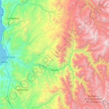
Name: Vicuña topographic map, elevation, terrain.
Average elevation: 1,973 m
Minimum elevation: 0 m
Maximum elevation: 5,623 m
Make a donation
Other topographic maps
Click on a map to view its topography, its elevation and its terrain.
Make a donation
Cerro Las Tórtolas
Chile > Coquimbo Region > Provincia de Elqui > Vicuña
Cerro Las Tórtolas is a peak at the border of Argentina and Chile with an elevation of 6,145 metres (20,161 ft) metres and located at the Central Andes. It is on the border of the Argentinean province of San Juan and Chilean province of Elqui. Its slopes are within the administrative boundaries of Argentinean…
Average elevation: 5,610 m
Make a donation
Guanaqueros
Chile > Coquimbo Region > Provincia de Elqui > Coquimbo > Guanaqueros
Average elevation: 63 m