Sicily topographic map
Interactive map
Click on the map to display elevation.
Sicily
According to the Regional Agency for Waste and Water, on 10 August 1999, the weather station of Catenanuova (EN) recorded an unofficial maximum temperature of 48.5 °C (119 °F). On 11 August 2021, a new highest temperature record for Europe with a reading of 48.8 °C (119.8 °F) was set near the city of Syracuse. Total precipitation is highly variable, generally increasing with elevation. In general, the southern and southeast coast receives the least rainfall (less than 50 cm (20 in)), and the northern and northeastern highlands the most (over 100 cm (39 in)).
About this map
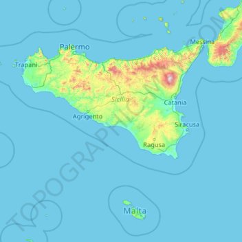
Name: Sicily topographic map, elevation, terrain.
Location: Sicily, Italy (35.49295 11.92586 38.81766 15.65308)
Average elevation: 93 m
Minimum elevation: -1 m
Maximum elevation: 3,218 m
Other topographic maps
Click on a map to view its topography, its elevation and its terrain.
Rieti
The province is largely mountainous with the Monti della Duchessa and the Monti del Cicolano ranges in the south with Monte Nuria and Monte Giano, the Monti Reatini range with Monte Terminillo (2217 m) in the north in part of the Abruzzese Apennines, and Monti della Laga (2458 m) to the east on the border with…
Average elevation: 712 m
Großhorn - Corno Grande
Italy > Trentino-Alto Adige/Südtirol > South Tyrol > Graun - Curon Venosta
Average elevation: 2,295 m
Veneto
The climate changes significantly from one area to another: while it is continental on the plains, it is milder along the Adriatic coast; around the Lake Garda and in the hilly areas. The lowlands are often covered by thick fog, in Winter; precipitations that are scarce – 750 mm per year – close to the…
Average elevation: 587 m
Madonna di Rocca Vecchia
Italy > Apulia > Melendugno > Madonna di Rocca Vecchia
Average elevation: 6 m
Genoa
The city of Genoa covers an area of 243 square kilometres (94 sq mi) between the Ligurian Sea and the Apennine Mountains. The city stretches along the coast for about 30 kilometres (19 mi) from the neighbourhood of Voltri to Nervi, and for 10 kilometres (6.2 mi) from the coast to the north along the valleys…
Average elevation: 333 m
Courmayeur
Italy > Aosta Valley > Courmayeur
At an elevation of 1,224 m (4,016 ft) above sea level, it is located at the foot of the southern side of Mont Blanc, at 4,810 m (15,781 ft) the highest point in the Alps and western Europe (see Seven Summits), and is crossed by the Dora Baltea (fr. Doire baltée) river.
Average elevation: 2,366 m