
Make a donation
Lagrangeville topographic map
Click on the map to display elevation.
Make a donation
About this map
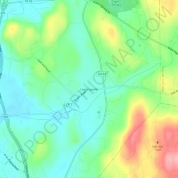
Name: Lagrangeville topographic map, elevation, terrain.
Average elevation: 136 m
Minimum elevation: 93 m
Maximum elevation: 226 m
Make a donation
Other topographic maps
Click on a map to view its topography, its elevation and its terrain.
Town of Pawling
United States > New York > Dutchess County
The eastern and western section of the towns are high and hilly, with the Great Swamp and Harlem Valley in the middle, where the village of Pawling is located. The highest elevation in town is Observatory Hill, at 1,332 feet (406 m) above sea level; the lowest is 420 feet (130 m), in the Great Swamp, along the…
Average elevation: 243 m
Hillside Lake
United States > New York > Dutchess County > Town of East Fishkill > Hillside Lake
Average elevation: 103 m
Make a donation
Make a donation
Make a donation
Town of North East
United States > New York > Dutchess County
Brace Mountain's 2,311-foot (704 m) summit, near the Connecticut state line in the northeastern corner of town, is the highest point in Dutchess County. The lowest elevation is 530 feet (160 m), along Shekomeko Creek at the Pine Plains town line.
Average elevation: 267 m
Dover Plains
United States > New York > Dutchess County > Dover Plains > Bains Corner
Average elevation: 149 m
Staatsburg
United States > New York > Dutchess County > Town of Hyde Park > Staatsburg
Average elevation: 25 m
City of Poughkeepsie
United States > New York > Dutchess County
According to the United States Census Bureau, the city has an area of 5.7 square miles (14.8 km2), of which 5.1 square miles (13.3 km2) is land, and 0.23 square miles (0.6 km2) (comprising 10.05%) is water. Poughkeepsie lies approximately 75 miles (121 km) north of the center of the New York megacity. It is…
Average elevation: 49 m
Make a donation
Hydepark Recreations
United States > New York > Dutchess County > Town of Hyde Park
Average elevation: 66 m
Make a donation
Town of Fishkill
United States > New York > Dutchess County
According to the United States Census Bureau, the town has a total area of 32.0 square miles (82.9 km2), of which 27.3 square miles (70.8 km2) is land and 4.7 square miles (12.1 km2), or 14.55%, is water. The elevation of the town varies from sea level along the Hudson River (Fishkill Waterfront, Fishkill…
Average elevation: 178 m
Make a donation
City of Poughkeepsie
United States > New York > Dutchess County
According to the United States Census Bureau, the city has an area of 5.7 square miles (14.8 km2), of which 5.1 square miles (13.3 km2) is land, and 0.23 square miles (0.6 km2) (comprising 10.05%) is water. Poughkeepsie lies approximately 75 miles (121 km) north of the center of the New York megacity. It is…
Average elevation: 49 m
Hopewell Junction
United States > New York > Dutchess County > Town of East Fishkill > Hopewell Junction
Average elevation: 83 m
Make a donation
Town of Fishkill
United States > New York > Dutchess County
According to the United States Census Bureau, the town has a total area of 32.0 square miles (82.9 km2), of which 27.3 square miles (70.8 km2) is land and 4.7 square miles (12.1 km2), or 14.55%, is water. The elevation of the town varies from sea level along the Hudson River (Fishkill Waterfront, Fishkill…
Average elevation: 178 m
Make a donation
Make a donation
City of Poughkeepsie
United States > New York > Dutchess County
According to the United States Census Bureau, the city has an area of 5.7 square miles (14.8 km2), of which 5.1 square miles (13.3 km2) is land, and 0.23 square miles (0.6 km2) (comprising 10.05%) is water. Poughkeepsie lies approximately 75 miles (121 km) north of the center of the New York megacity. It is…
Average elevation: 49 m
Make a donation
Town of Pawling
United States > New York > Dutchess County
The eastern and western section of the towns are high and hilly, with the Great Swamp and Harlem Valley in the middle, where the village of Pawling is located. The highest elevation in town is Observatory Hill, at 1,332 feet (406 m) above sea level; the lowest is 420 feet (130 m), in the Great Swamp, along the…
Average elevation: 243 m
Wassaic
United States > New York > Dutchess County > Town of Amenia > Wassaic
Average elevation: 235 m
Make a donation
Village of Red Hook
United States > New York > Dutchess County > Town of Red Hook
Average elevation: 66 m
Make a donation
Rhinecliff
United States > New York > Dutchess County > Town of Rhinebeck
The hamlet is demarcated by large agricultural and wooded area to the north, east, and south, and bounded by the Hudson River on the west. Steep topography, formed by contorted slate ridges and valleys, define the site-specific and seemingly random orientation of the small, frame nineteenth-century houses and…
Average elevation: 19 m
Make a donation
Hopewell Junction
United States > New York > Dutchess County > Town of East Fishkill > Hopewell Junction
Average elevation: 83 m
Barrytown
United States > New York > Dutchess County > Town of Red Hook > Barrytown
Average elevation: 26 m
Make a donation
Town of North East
United States > New York > Dutchess County
Brace Mountain's 2,311-foot (704 m) summit, near the Connecticut state line in the northeastern corner of town, is the highest point in Dutchess County. The lowest elevation is 530 feet (160 m), along Shekomeko Creek at the Pine Plains town line.
Average elevation: 267 m
Make a donation