Geolocate

Biu topographic map

Interactive map

Click on the map to display elevation.

Biu

Biu is a town and a Local Government Area (LGA) in southern Borno State of Nigeria. The town is the administrative center of the LGA and was once the capital of the Biu kingdom, and is now capital of the Biu Emirate. Biu lies on the Biu Plateau at an average elevation of 626 meters. The region is semi-arid.

Wikipedia (CC-BY-SA 3.0)

About this map

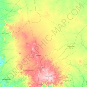
Name: Biu topographic map, elevation, terrain.

Location: Biu, Borno State, 603231, Nigeria (10.56332 11.63215 11.11954 12.46474)

Average elevation: 506 m

Minimum elevation: 271 m

Maximum elevation: 888 m

Other topographic maps

Click on a map to view its topography, its elevation and its terrain.

Afriski

Nigeria > Borno State > Marte > Muwalli

Average elevation: 291 m

Pija

Nigeria > Borno State > Kwaya Kusar > Bilazi

Average elevation: 255 m

Mandalla

Nigeria > Borno State > Guzamala > Moduri

Average elevation: 297 m

Mallam Fatori

Nigeria > Borno State > Abadam > Kessa'A

Average elevation: 283 m

Kirbirum

Nigeria > Borno State > Mobbar > Asaga

Average elevation: 304 m

Kaula

Nigeria > Borno State > Abadam

Average elevation: 284 m

Bukar

Nigeria > Borno State > Hawul > Grim Damchoba > Bulama

Average elevation: 542 m

Burari

Nigeria > Borno State > Bama > Soye > Burari

Average elevation: 327 m