
Thank you for supporting this site ❤️
Make a donation
Make a donation
Mauston topographic map
Click on the map to display elevation.
Thank you for supporting this site ❤️
Make a donation
Make a donation
Mauston
Mauston is located at 43°48′N 90°5′W / 43.800°N 90.083°W / 43.800; -90.083 (43.798, -90.077). It is in the Central Standard time zone. Elevation is 883 feet.
Thank you for supporting this site ❤️
Make a donation
Make a donation
About this map
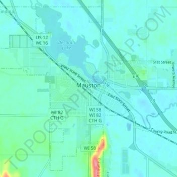
Name: Mauston topographic map, elevation, terrain.
Location: Mauston, Juneau County, Wisconsin, 53948, United States (43.77398 -90.11176 43.81855 -90.04509)
Average elevation: 271 m
Minimum elevation: 260 m
Maximum elevation: 344 m
Thank you for supporting this site ❤️
Make a donation
Make a donation
Other topographic maps
Click on a map to view its topography, its elevation and its terrain.