
Death Valley topographic map
Interactive map
Click on the map to display elevation.
Death Valley
Death Valley's Badwater Basin is the point of lowest elevation in North America, at 282 feet (86 m) below sea level. It is 84.6 miles (136.2 km) east-southeast of Mount Whitney — the highest point in the contiguous United States, with an elevation of 14,505 feet (4,421 m). On the afternoon of July 10, 1913, the United States Weather Bureau recorded a high temperature of 134 °F (56.7 °C) at Furnace Creek in Death Valley, which stands as the highest ambient air temperature ever recorded on the surface of the Earth. This reading, however, and several others taken in that period are disputed by some modern experts.
About this map
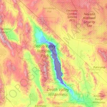
Name: Death Valley topographic map, elevation, terrain.
Location: Death Valley, California, 92328, United States (35.55151 -117.65105 37.29602 -116.25764)
Average elevation: 1,085 m
Minimum elevation: -83 m
Maximum elevation: 3,329 m
Other topographic maps
Click on a map to view its topography, its elevation and its terrain.
Allensworth
United States > California > Tulare County
Allensworth sits at an elevation of 213 feet (65 m), the same elevation as the huge and historically important Tulare Lake shore when it was full. The community is located in the ZIP Code 93219 and in the area code 661.
Average elevation: 63 m