
Redondela topographic map
Click on the map to display elevation.
About this map
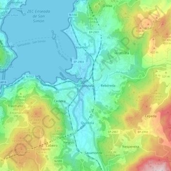
Name: Redondela topographic map, elevation, terrain.
Location: Redondela, Vigo, Pontevedra, Galicia, 36800, Spain (42.24422 -8.64860 42.32422 -8.56860)
Average elevation: 188 m
Minimum elevation: 0 m
Maximum elevation: 670 m
Other topographic maps
Click on a map to view its topography, its elevation and its terrain.
Vigo
Vigo has a transitional climate between the oceanic climate "Cfb" and the warm-summer Mediterranean climate "Csb" according to the Köppen climate classification. Although Vigo is the rainiest city in Galicia, with its noticeable drying trend in the summer, Vigo's climate is more similar to the variant of the…
Average elevation: 137 m
Vigo
Vigo has a transitional climate between the oceanic climate "Cfb" and the warm-summer Mediterranean climate "Csb" according to the Köppen climate classification. Although Vigo is the rainiest city in Galicia, with its noticeable drying trend in the summer, Vigo's climate is more similar to the variant of the…
Average elevation: 124 m
Vigo
Vigo has a transitional climate between the oceanic climate "Cfb" and the warm-summer Mediterranean climate "Csb" according to the Köppen climate classification. Although Vigo is the rainiest city in Galicia, with its noticeable drying trend in the summer, Vigo's climate is more similar to the variant of the…
Average elevation: 137 m