
Keighley Moor Reservoir topographic map
Interactive map
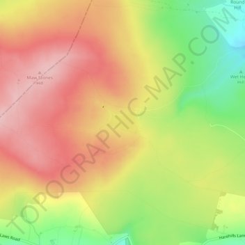
Click on the map to display elevation.
About this map
Name: Keighley Moor Reservoir topographic map, elevation, terrain.
Average elevation: 366 m
Minimum elevation: 266 m
Maximum elevation: 439 m
Other topographic maps
Click on a map to view its topography, its elevation and its terrain.
Ponden Reservoir
United Kingdom > England > Bradford > Keighley > Stanbury
Ponden Reservoir, Keighley, Stanbury, Bradford, West Yorkshire, England, United Kingdom
Average elevation: 313 m
Cackleshaw
United Kingdom > England > Bradford > Keighley > Oakworth > Cackleshaw
Cackleshaw, Keighley, Oakworth, Bradford, West Yorkshire, England, BD22 7JP, United Kingdom
Average elevation: 219 m
High Utley
United Kingdom > England > Bradford > Keighley > High Utley
High Utley, Keighley, Bradford, West Yorkshire, Yorkshire and the Humber, England, BD20 6ES, United Kingdom
Average elevation: 169 m