
Bell Farm topographic map
Interactive map
Click on the map to display elevation.
About this map
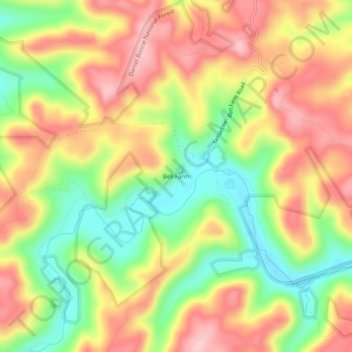
Name: Bell Farm topographic map, elevation, terrain.
Location: Bell Farm, McCreary County, Kentucky, United States (36.64969 -84.69496 36.68969 -84.65496)
Average elevation: 369 m
Minimum elevation: 273 m
Maximum elevation: 455 m
Other topographic maps
Click on a map to view its topography, its elevation and its terrain.
Cumberland Falls
United States > Kentucky > McCreary County
Cumberland Falls, McCreary County, Kentucky, 42634, United States
Average elevation: 312 m
Stearns
United States > Kentucky > McCreary County
Stearns, McCreary County, Kentucky, United States
Average elevation: 392 m
Yamacraw
United States > Kentucky > McCreary County
Yamacraw, McCreary County, Kentucky, 42647, United States
Average elevation: 315 m
Flat Rock
United States > Kentucky > McCreary County
Flat Rock, McCreary County, Kentucky, 42653, United States
Average elevation: 374 m
Strunk
United States > Kentucky > McCreary County > Strunk
Strunk, McCreary County, Kentucky, 42649, United States
Average elevation: 410 m
Pine Knot
United States > Kentucky > McCreary County
Pine Knot, McCreary County, Kentucky, United States
Average elevation: 399 m
Whitley City
United States > Kentucky > McCreary County
Whitley City, McCreary County, Kentucky, 42563, United States
Average elevation: 390 m