
Thank you for supporting this site ❤️
Make a donation
Make a donation
Wildhorse Ridge topographic map
Click on the map to display elevation.
Thank you for supporting this site ❤️
Make a donation
Make a donation
About this map
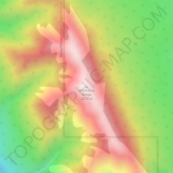
Name: Wildhorse Ridge topographic map, elevation, terrain.
Location: Wildhorse Ridge, Clearwater County, Alberta, Canada (51.68621 -115.41338 51.68631 -115.41328)
Average elevation: 1,911 m
Minimum elevation: 1,532 m
Maximum elevation: 2,248 m
Thank you for supporting this site ❤️
Make a donation
Make a donation
Other topographic maps
Click on a map to view its topography, its elevation and its terrain.
Thank you for supporting this site ❤️
Make a donation
Make a donation
Cutoff Creek Equestrian Staging Public Land Recreation Area
Canada > Alberta > Clearwater County
Average elevation: 1,509 m
Thank you for supporting this site ❤️
Make a donation
Make a donation
Hummingbird Public Land Recreation Area
Canada > Alberta > Clearwater County
Average elevation: 1,830 m
Thank you for supporting this site ❤️
Make a donation
Make a donation