
Thank you for supporting this site ❤️
Make a donation
Make a donation
Cravans topographic map
Click on the map to display elevation.
Thank you for supporting this site ❤️
Make a donation
Make a donation
About this map
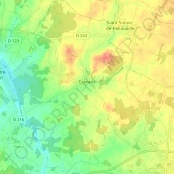
Name: Cravans topographic map, elevation, terrain.
Average elevation: 35 m
Minimum elevation: 14 m
Maximum elevation: 55 m
Thank you for supporting this site ❤️
Make a donation
Make a donation
Other topographic maps
Click on a map to view its topography, its elevation and its terrain.
Chaillé
France > Nouvelle-Aquitaine > Charente-Maritime > Saint-Georges-du-Bois
Average elevation: 52 m
Les Grandes Rivières
France > Nouvelle-Aquitaine > Charente-Maritime > Sainte-Soulle
Average elevation: 25 m
Thank you for supporting this site ❤️
Make a donation
Make a donation