
Thank you for supporting this site ❤️
Make a donation
Make a donation
Winterreute topographic map
Click on the map to display elevation.
Thank you for supporting this site ❤️
Make a donation
Make a donation
About this map
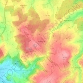
Name: Winterreute topographic map, elevation, terrain.
Average elevation: 612 m
Minimum elevation: 540 m
Maximum elevation: 655 m
Thank you for supporting this site ❤️
Make a donation
Make a donation
Other topographic maps
Click on a map to view its topography, its elevation and its terrain.
88400
Deutschland > Baden-Württemberg > Landkreis Biberach > Biberach an der Riß > Bergerhausen
Average elevation: 590 m