
Thank you for supporting this site ❤️
Make a donation
Make a donation
Chembe topographic map
Click on the map to display elevation.
Thank you for supporting this site ❤️
Make a donation
Make a donation
About this map
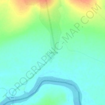
Name: Chembe topographic map, elevation, terrain.
Location: Chembe, Chembe District, Luapula Province, Zambia (-11.98651 28.72607 -11.94651 28.76607)
Average elevation: 1,064 m
Minimum elevation: 1,050 m
Maximum elevation: 1,094 m
Thank you for supporting this site ❤️
Make a donation
Make a donation
Other topographic maps
Click on a map to view its topography, its elevation and its terrain.
Lake Bangweulu
Bangweulu — 'where the water sky meets the sky' — is one of the world's great wetland systems, comprising Lake Bangweulu, the Bangweulu Swamps and the Bangweulu Flats or floodplain. Situated in the upper Congo River basin in Zambia, the Bangweulu system covers an almost completely flat area roughly the…
Average elevation: 1,172 m