
Thank you for supporting this site ❤️
Make a donation
Make a donation
La Mothe topographic map
Click on the map to display elevation.
Thank you for supporting this site ❤️
Make a donation
Make a donation
About this map
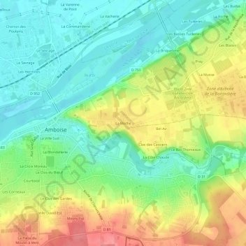
Name: La Mothe topographic map, elevation, terrain.
Average elevation: 82 m
Minimum elevation: 50 m
Maximum elevation: 129 m
Thank you for supporting this site ❤️
Make a donation
Make a donation
Other topographic maps
Click on a map to view its topography, its elevation and its terrain.
Tour Heurtault
France > Centre-Val de Loire > Indre-et-Loire > Amboise > La Ville-Sud
Average elevation: 71 m
Tour Heurtault
France > Centre-Val de Loire > Indre-et-Loire > Amboise > La Ville-Sud
Average elevation: 71 m