
Thank you for supporting this site ❤️
Make a donation
Make a donation
Feldbach topographic map
Click on the map to display elevation.
Thank you for supporting this site ❤️
Make a donation
Make a donation
About this map
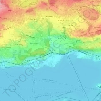
Name: Feldbach topographic map, elevation, terrain.
Location: Feldbach, Hombrechtikon, Bezirk Meilen, Zürich, 8714, Schweiz (47.22092 8.76553 47.26092 8.80553)
Average elevation: 452 m
Minimum elevation: 402 m
Maximum elevation: 559 m
Thank you for supporting this site ❤️
Make a donation
Make a donation
Other topographic maps
Click on a map to view its topography, its elevation and its terrain.
Zürichsee
Schweiz > Zürich > Bezirk Meilen
Das schmale Tal, in dem der See liegt, ist auf der Südwestseite von den Höhenzügen des Etzel und des Albis und auf der Nordostseite von der Hügellandschaft des Zürcher Oberlandes und vom Pfannenstiel flankiert. An beiden Talhängen liegen Hangterrassen, die von Seitenmoränen gebildet worden sind. Der…
Average elevation: 553 m