
Thank you for supporting this site ❤️
Make a donation
Make a donation
Les Verneries topographic map
Click on the map to display elevation.
Thank you for supporting this site ❤️
Make a donation
Make a donation
About this map
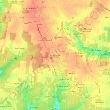
Name: Les Verneries topographic map, elevation, terrain.
Average elevation: 109 m
Minimum elevation: 73 m
Maximum elevation: 124 m
Thank you for supporting this site ❤️
Make a donation
Make a donation
Other topographic maps
Click on a map to view its topography, its elevation and its terrain.
37210
France > Centre-Val de Loire > Indre-et-Loire > Vouvray > La Croix de Miauzay
Average elevation: 90 m