
Thank you for supporting this site ❤️
Make a donation
Make a donation
South (Middle) Sister topographic map
Click on the map to display elevation.
Thank you for supporting this site ❤️
Make a donation
Make a donation
About this map
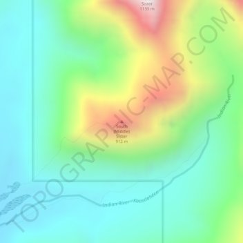
Name: South (Middle) Sister topographic map, elevation, terrain.
Location: South (Middle) Sister, Sitka, Alaska, United States (57.08936 -135.25439 57.08946 -135.25429)
Average elevation: 368 m
Minimum elevation: 65 m
Maximum elevation: 1,093 m
Thank you for supporting this site ❤️
Make a donation
Make a donation
Other topographic maps
Click on a map to view its topography, its elevation and its terrain.