
Thank you for supporting this site ❤️
Make a donation
Make a donation
Alvesta kommun topographic map
Click on the map to display elevation.
Thank you for supporting this site ❤️
Make a donation
Make a donation
About this map
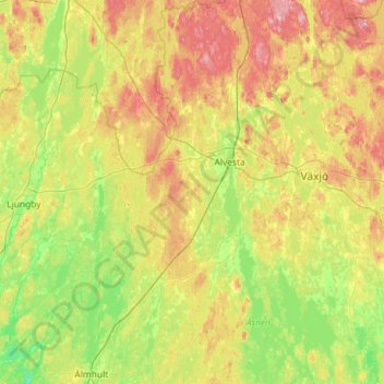
Name: Alvesta kommun topographic map, elevation, terrain.
Location: Alvesta kommun, Kronoberg County, Sweden (56.53402 14.27828 57.16336 14.69556)
Average elevation: 169 m
Minimum elevation: 105 m
Maximum elevation: 306 m
Thank you for supporting this site ❤️
Make a donation
Make a donation
Other topographic maps
Click on a map to view its topography, its elevation and its terrain.