
Halifax topographic map
Click on the map to display elevation.
About this map
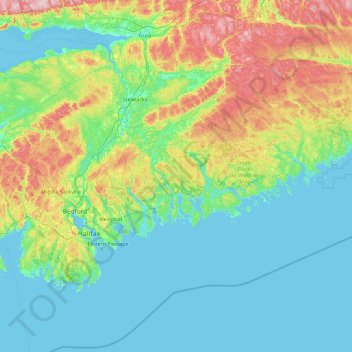
Name: Halifax topographic map, elevation, terrain.
Location: Halifax, Halifax County, Nova Scotia, Canada (44.21437 -63.77780 45.49437 -62.49780)
Average elevation: 60 m
Minimum elevation: -3 m
Maximum elevation: 293 m
Other topographic maps
Click on a map to view its topography, its elevation and its terrain.
Sable Island
Canada > Nova Scotia > Halifax County > Sable Island
Sable Island is a narrow, crescent-shaped sandbar with a surface area estimated around 34 km2 (13 sq mi). Despite being approximately 43.15 km (26.81 mi) long, it is only 1.21 km (0.75 mi) across at its widest point. The maximum elevation is about 30 m (98 ft). The long crescent-shaped island rises gently from…
Average elevation: 0 m
East Margaretsville
Canada > Nova Scotia > Municipality of the County of Kings
Average elevation: 91 m
Halifax Stanfield International Airport
Canada > Nova Scotia > Halifax County > Goffs
Average elevation: 118 m
Margaree Valley
Canada > Nova Scotia > Municipality of the County of Inverness
Average elevation: 223 m
Lumsden Pond
Canada > Nova Scotia > Municipality of the County of Kings > Lumsden Dam
Average elevation: 170 m
Kejimkujik National Park Seaside
Canada > Nova Scotia > Queens County > Port Joli
Average elevation: 9 m
Bridgewater
Canada > Nova Scotia > Lunenburg County
Bridgewater spans the width of the LaHave River Valley and is dominated by hills that lead down to the river. Elevations range from 5 metres above sea level at the river, to nearly 110 m at the southwestern border. Like much of Southern Nova Scotia, the surrounding area is characterized by rolling drumlins…
Average elevation: 56 m
Princton Heights Park
Canada > Nova Scotia > Municipality of Colchester > Salmon River
Average elevation: 59 m
Broad Cove Chapel
Canada > Nova Scotia > Municipality of the County of Inverness
Average elevation: 84 m
Bras d'Or Lake
Canada > Nova Scotia > Municipality of the County of Richmond > Red Islands
Average elevation: 29 m
Cross Mountain Road
Canada > Nova Scotia > Municipality of the County of Cumberland
Average elevation: 237 m