
Thank you for supporting this site ❤️
Make a donation
Make a donation
Borås topographic map
Click on the map to display elevation.
Thank you for supporting this site ❤️
Make a donation
Make a donation
About this map
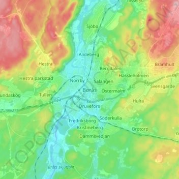
Name: Borås topographic map, elevation, terrain.
Location: Borås, Borås kommun, Västra Götaland County, 503 31, Sweden (57.56108 12.78074 57.88108 13.10074)
Average elevation: 196 m
Minimum elevation: 64 m
Maximum elevation: 331 m
Thank you for supporting this site ❤️
Make a donation
Make a donation
Other topographic maps
Click on a map to view its topography, its elevation and its terrain.