
Make a donation
Ball Ground topographic map
Click on the map to display elevation.
Make a donation
Ball Ground
According to the United States Census Bureau as of 2020, Ball Ground has a total area of 6.3 sq mi (16 km2), of which 0.04 sq mi (0.10 km2), or 0.63%, is water. The city's elevation averages around 1,100 ft (340 m) above sea level, ranging from just over 1,000 ft (300 m) in the valleys to around 1,200 ft (370 m) on several hilltops within the city. Unlike most other parts of Cherokee County, Ball Ground is not in a floodplain and has no typically flood prone areas. To protect the water and surrounding lands, the city government has ordinances in place for stream buffer protection, watershed protection, and wetland protection.
Make a donation
About this map
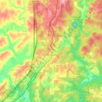
Name: Ball Ground topographic map, elevation, terrain.
Location: Ball Ground, Cherokee County, Georgia, United States (34.31118 -84.41254 34.37075 -84.32178)
Average elevation: 331 m
Minimum elevation: 243 m
Maximum elevation: 414 m
Make a donation
Other topographic maps
Click on a map to view its topography, its elevation and its terrain.
Make a donation
Make a donation