
Make a donation
Lake Pleasant topographic map
Click on the map to display elevation.
Make a donation
About this map
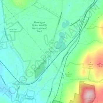
Name: Lake Pleasant topographic map, elevation, terrain.
Average elevation: 116 m
Minimum elevation: 39 m
Maximum elevation: 327 m
Make a donation
Other topographic maps
Click on a map to view its topography, its elevation and its terrain.
Make a donation
Rocky Mountain Park
United States > Massachusetts > Franklin County > Greenfield > Greenfield
Average elevation: 68 m
Leverett
United States > Massachusetts > Franklin County
According to the United States Census Bureau, the town has a total area of 23.0 square miles (60 km2), of which 22.9 square miles (59 km2) are land and 0.1-square-mile (0.26 km2) (0.61%) is water. Leverett is located on the edge of the Pioneer Valley and the hills of northwestern Massachusetts, just east of…
Average elevation: 220 m
Lake Wyola
United States > Massachusetts > Franklin County > Shutesbury > Locks Village
Average elevation: 283 m
Make a donation
Osgood Brook
United States > Massachusetts > Franklin County > Wendell > Wendell Depot
Average elevation: 245 m