
Thank you for supporting this site ❤️
Make a donation
Make a donation
Hoppenrade topographic map
Click on the map to display elevation.
Thank you for supporting this site ❤️
Make a donation
Make a donation
About this map
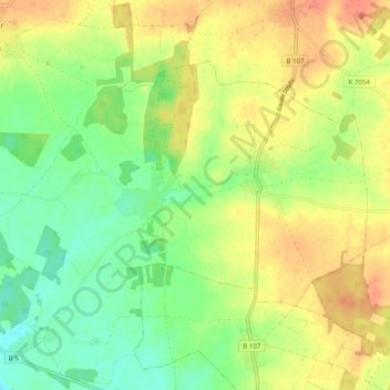
Name: Hoppenrade topographic map, elevation, terrain.
Location: Hoppenrade, Plattenburg, Prignitz, Brandenburg, Deutschland (53.01480 12.01579 53.05562 12.11432)
Average elevation: 61 m
Minimum elevation: 37 m
Maximum elevation: 85 m
Thank you for supporting this site ❤️
Make a donation
Make a donation
Other topographic maps
Click on a map to view its topography, its elevation and its terrain.