
Thank you for supporting this site ❤️
Make a donation
Make a donation
Hemmer topographic map
Click on the map to display elevation.
Thank you for supporting this site ❤️
Make a donation
Make a donation
About this map
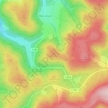
Name: Hemmer topographic map, elevation, terrain.
Average elevation: 610 m
Minimum elevation: 456 m
Maximum elevation: 745 m
Thank you for supporting this site ❤️
Make a donation
Make a donation
Other topographic maps
Click on a map to view its topography, its elevation and its terrain.
Esenbeck
Deutschland > Nordrhein-Westfalen > Hochsauerlandkreis > Schmallenberg > Obersorpe
Average elevation: 687 m