
Thank you for supporting this site ❤️
Make a donation
Make a donation
Mennighüffen topographic map
Click on the map to display elevation.
Thank you for supporting this site ❤️
Make a donation
Make a donation
About this map
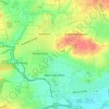
Name: Mennighüffen topographic map, elevation, terrain.
Average elevation: 72 m
Minimum elevation: 48 m
Maximum elevation: 109 m
Thank you for supporting this site ❤️
Make a donation
Make a donation
Other topographic maps
Click on a map to view its topography, its elevation and its terrain.
Thank you for supporting this site ❤️
Make a donation
Make a donation
Wasserschloss Ulenburg
Deutschland > Nordrhein-Westfalen > Kreis Herford > Löhne > Westscheid
Average elevation: 73 m
Mahnen
Deutschland > Nordrhein-Westfalen > Kreis Herford > Löhne > Bischofshagen
Average elevation: 83 m