
Thank you for supporting this site ❤️
Make a donation
Make a donation
Unterriexingen topographic map
Click on the map to display elevation.
Thank you for supporting this site ❤️
Make a donation
Make a donation
Unterriexingen
Zu Unterriexingen gehören außerdem Gebäude auf dem Hohberg, die Frauenkirche auf der Höhe südwestlich des Ortes und Aussiedlerhöfe im Westen.
Thank you for supporting this site ❤️
Make a donation
Make a donation
About this map
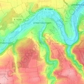
Name: Unterriexingen topographic map, elevation, terrain.
Average elevation: 250 m
Minimum elevation: 184 m
Maximum elevation: 318 m
Thank you for supporting this site ❤️
Make a donation
Make a donation
Other topographic maps
Click on a map to view its topography, its elevation and its terrain.
Aichholzhof
Deutschland > Baden-Württemberg > Landkreis Ludwigsburg > Markgröningen > Aichholzhof
Average elevation: 286 m