
Thank you for supporting this site ❤️
Make a donation
Make a donation
Dedham Vale AONB topographic map
Click on the map to display elevation.
Thank you for supporting this site ❤️
Make a donation
Make a donation
About this map
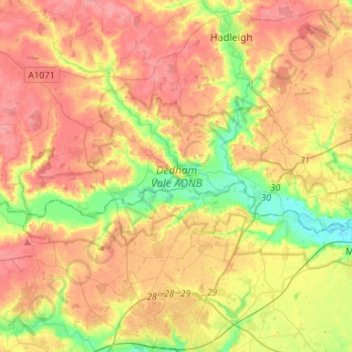
Name: Dedham Vale AONB topographic map, elevation, terrain.
Location: Dedham Vale AONB, Babergh, Suffolk, England, United Kingdom (51.93675 0.79430 52.02260 1.05921)
Average elevation: 44 m
Minimum elevation: -2 m
Maximum elevation: 79 m
Thank you for supporting this site ❤️
Make a donation
Make a donation
Other topographic maps
Click on a map to view its topography, its elevation and its terrain.
Constable 'The Haywain' viewing point
United Kingdom > England > Suffolk > Babergh > East Bergholt > Flatford
Average elevation: 15 m
Thank you for supporting this site ❤️
Make a donation
Make a donation
Thank you for supporting this site ❤️
Make a donation
Make a donation
Thank you for supporting this site ❤️
Make a donation
Make a donation
Flatford
United Kingdom > England > Suffolk > Babergh > East Bergholt > Flatford
Average elevation: 22 m
Long Melford-Bury St Edmunds branch line
United Kingdom > England > Suffolk > Babergh > Lavenham
Average elevation: 70 m
Mill Green
United Kingdom > England > Suffolk > Babergh > Edwardstone > Mill Green
Average elevation: 59 m
Thank you for supporting this site ❤️
Make a donation
Make a donation